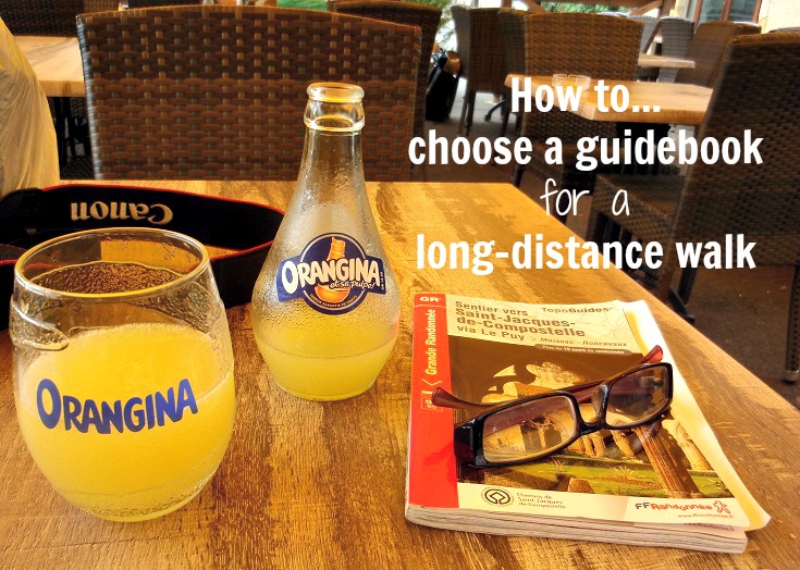
For me, choosing a guidebook to use on a long-distance walk in France is always simple—I’m a dedicated TopoGuide fan!
But there are several other options and another popular choice among walkers I meet is the Miam Miam Dodo guidebook.
Of course, we all look for different things in a guidebook and what appeals to me may not suit your needs at all.
The most important thing for me is the topographic map and I will always buy a TopoGuide if one has been written for the walk I want to do. (Scroll to the bottom of this post for a quick guide to reading topographic maps.)
Many people start a walk with a schedule and a list of villages they plan to stay at along the way but prefer not to book accommodation too far in advance—remaining flexible in case of bad weather, injury or needing (or not needing) a rest day. If this sounds like you, the layout of the Miam Miam Dodo guidebook with maps and accommodation listings on facing pages may suit you much better.
To get a better feel for the differences between the TopoGuide and the Miam Miam Dodo guidebook, I carried both as I walked the GR 70 Chemin de Stevenson and the comparison below is based on these books. Some inclusions, such as where to rent a donkey, will not be applicable to their guidebooks covering other walks.
The FFRandonnée TopoGuide
Published by the Fédération Française de la Randonnée Pédestre (the non-profit organisation that oversees the maintenance of all walking paths in France), the TopoGuide includes—
- General hiking advice
- Public transport and taxi access, luggage transfers
- Where to rent a donkey (if you plan to travel as Robert Louis Stevenson did)
- Accommodation with telephone numbers (some addresses and websites are included)
- Supermarkets, restaurants, Tourist Offices and ATMs (not all ATMs accept foreign cards)
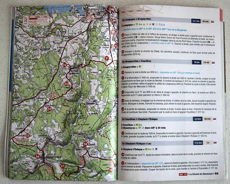
- Topographic maps which show the GR path, roads, all towns and villages and other useful landmarks.
- Walking notes which include the distances and time to walk (based on 4 kilometres per hour) between villages and a description of the terrain.
- The story of Robert Louis Stevenson’s walk from Le Monastier-sur-Gazeille to Saint-Jean-du-Gard in 1878 on which the GR 70 is based.
- Descriptive sections elaborating on the landscape and history of the landmarks and villages along the path.
What I like about the TopoGuide?
- I’m a big fan of topographic maps—they give a good sense of the terrain as well as showing roads and villages. I can see at a glance whether the path is hilly (and how steep the hills are) and where a nearby road might avoid a hill or a muddy section of track in the rain. I can see how many hamlets, villages and towns we’ll pass through, how big they are and, therefore, how likely it will be that we’ll find water or a café. I would find it difficult to plan a walk without a topographic map.
- The walking notes confirm (or correct) my interpretation of the map. Although I don’t usually read them as I walk (GR paths are generally well marked and easy to follow), I do check them each morning and use them to get my bearings throughout the day.
What I don’t like about the TopoGuide?
- It is written in French. This is not a complaint—we are, after all, walking in France. All the important information—town names, addresses, phone numbers, distances and times—are the same in any language and while my knowledge of French is reasonably good, I tend to skip over the history and descriptive sections. If your knowledge of French is very limited, you may struggle to absorb all the information it contains. In my perfect, fairy-tale world, there would be an English language version of this guidebook (I Love Walking in France guidebooks include a list of useful French phrases which will help you to make sense of the walking instructions.)
- The absence of an address on many of the accommodation listings makes it difficult to guess the location and assess their suitability. If you are booking accommodation a day or two in advance as you walk, then a name and telephone number (and an assumption it will be close to the path or you will be given directions when you book) may be all you need.
How to purchase a TopoGuide online
The Miam Miam Dodo guidebook
Published by Le Vieux Crayon, the Miam Miam Dodo guidebook covers both the GR 70 Chemin de Stevenson and the GR 700 Chemin de Régordane (also known as the Chemin de Saint-Gilles). It includes—
- General hiking advice
- Public transport access, luggage transfers
- Where to rent a donkey (if you plan to travel as Robert Louis Stevenson did)
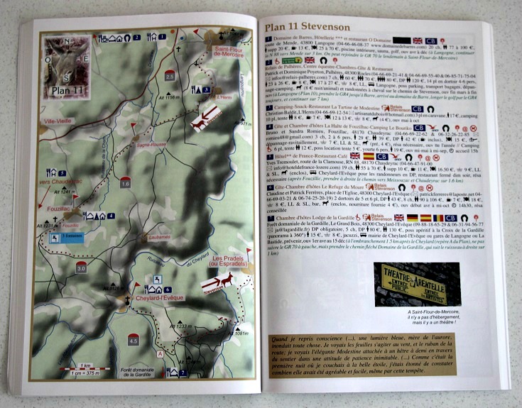
- Drawn maps which show the GR path, all towns and villages and other useful landmarks. Distances between villages is shown on the map. Climbs and descents are shown with >>> (red indicates up, green indicates down)
- Accommodation with telephone numbers, addresses and websites if applicable.
- Supermarkets, restaurants, pharmacies, Tourist Offices and ATMs (not all ATMs accept foreign cards).
- Public water fountains (l’eau potable)
- The story of Robert Louis Stevenson’s walk from Le Monastier-sur-Gazeille to Saint-Jean-du-Gard in 1878 on which the GR 70 is based.
- Descriptive sections elaborating on the landscape and history of the landmarks and villages along the path.
What I like about the Miam Miam Dodo guidebook?
- The guidebook is laid out with the map on the left and all services (accommodation, cafés etc) to be found in towns on that page are listed on the right. This makes it easy to find information relating to the part of the walk you are on. (I like this layout so much that I have moved accommodation listings in the I Love Walking in France guidebooks from their own section at the back and included them with the village they refer to.)
- Knowing which villages had a water fountain was a big plus on days when the temperature was over 30 degrees Celsius and we passed few cafés.
What I don’t like about the Miam Miam Dodo guidebook?
- Like the TopoGuide, it is written in French. And again, this is not a complaint as all the important information—town names, addresses, phone numbers, distances and times—are the same in any language. In this guide too, I tend to skip over the history and descriptive sections and if your knowledge of French is very limited, you may struggle to absorb all the information it contains.
- I don’t get any sense of the terrain from the maps. Very few sections are marked with the >>> arrows indicating hills, and without walking notes to describe the terrain, the maps give the impression that this walk is mostly flat. That is not the case.
How to purchase a Miam Miam Dodo guidebook online
Why would you buy an I Love Walking in France guidebook?
Obviously, I managed to walk the GR 70 Chemin de Stevenson without the benefit of owning one of my own guidebooks. But it required many days of researching and planning.
The process I used is described here and you can follow these steps to plan any long-distance walk.
If you’ve got better things to do (and because I wouldn’t miss an opportunity for a shameless plug), you’ll find everything you need to quickly and easily plan an itinerary, book accommodation—and much more—in an I Love Walking in France digital guidebook.
Some of the information is also available here on the website—
- What to expect on the walk
- Map of the path and its location in France
- My suggested itinerary, including tips for sightseeing and market days
- A list of all the towns and villages where you’ll find accommodation and the distances between them
- Practical tips for walking safely and considerately
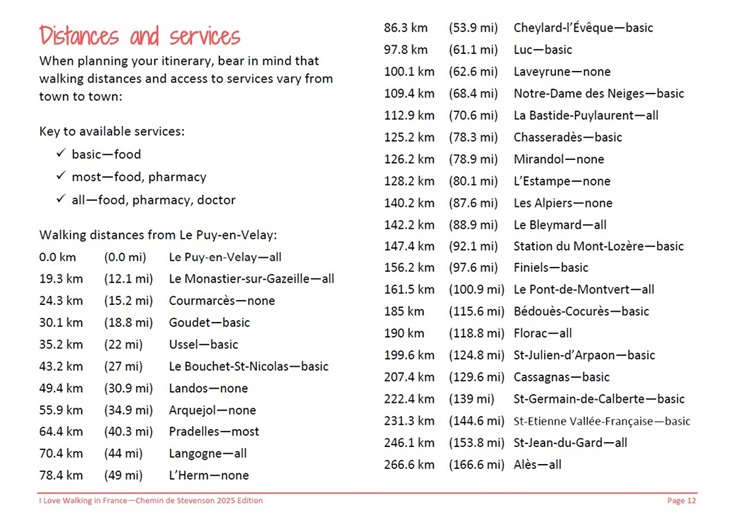
Inside an I Love Walking in France digital guidebook, you’ll also find—
- A complete packing list covering all the essential items you’ll need to take and a few optional extras
- Useful French phrases to help you book a taxi, book a room, ask about breakfast, order dinner, buy a train ticket and understand directions
- Dozens of photos
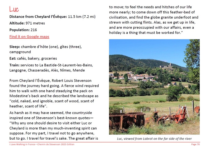
Each village has a dedicated section covering—
- Population (because a village of 35 will not have an ATM not matter how badly you need one)
- Accommodation—what will you find, hotels, chambre d’hôtes, gîtes or campgrounds… including website links
- Available services—cafés, bakeries, grocery stores, doctors, pharmacies, banks and ATMs
- Train and bus services, including website links to check or download timetables
- Taxi phone numbers
- Tourist Office location and website
- Market days and other festivals
- A brief history of the village and details of museums, churches and other attractions
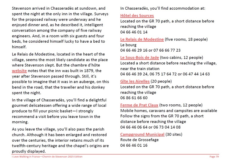
(Note: I Love Walking in France guidebooks do not include walking notes.)
How to purchase an I Love Walking in France guidebook online
How to read a topographic map
Most guidebooks can be broadly categorised as using either topographic maps, basic drawn maps or written walking notes (ie turn left after the church). I struggle with the last two but find topographic maps a breeze. I assumed this was true for everyone, but I recently read that the number one reason people don’t go hiking or venture off a marked walking path is because they find topographic maps too confusing.
TopoGuides contain lots of useful information so here are a few tips which, hopefully, will make the topographic maps easier to understand.
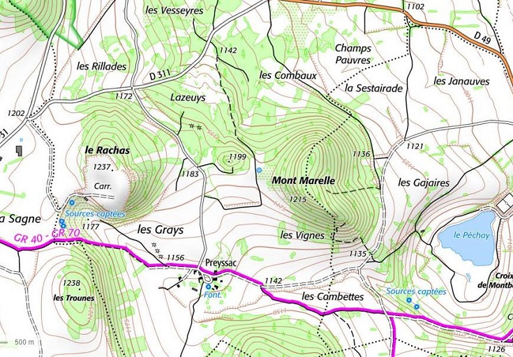
Topographic maps are marked with contour lines which indicate an elevation above sea level. Depending on the level of detail, this might be every 20 metres or every 50 metres. How closely spaced these contour lines are, is an indication of how hilly or flat the land is—the steeper the hill, the closer the contour lines. A map crowded with contour lines will be hilly, a map with few lines will be gentle and mostly flat.
As a walker, that’s a nice start but the important question is—am I going uphill or down? If the contour lines start to form circles and eventually a small ring, you will be headed uphill towards the summit (note how the contour lines form a tight circle around Mont Marelle.) If they start to spread out and lengthen, perhaps heading towards a blue line (stream or river), you will be walking downhill (note how the contour lines start to spread out towards the bottom of Mont Marelle near les Vignes.) Elevations are usually displayed every 50 or 100 metres and at the summit of each hill, allowing you to confirm ascents and descents.
The background of a topographic map will show how the land is being used—tiny trees on a green background indicate a forest, large geometric patches usually indicate fields and dots or crosses often indicate agriculture or a crop of some kind (rather than cattle). Buildings are represented by tiny black squares and you can see if a village covers a few streets, and may have a café (I wouldn’t expect to find a café in Preyssac) or is actually just two houses and a barn.

Roads will be shown on the map—usually solid orange for a major road (note the D49 departmental road in the north-east corner), solid white for a quieter road (note the D311 in the north-west section) and dashed lines for country lanes (note the minor road to the west of les Cajaires which travels south-west towards les Combettes). This will allow you to see where the path crosses the road or where you might find a shortcut. This can be very handy in wet weather when walking paths become slippery and muddy. (Note that the GR 70 joins a minor road a short distance before reaching Preyssac. Shortly after leaving Preyssac, the GR 70 leaves the road and takes a short cut to the south of les Combettes. If this path was muddy, it would be possible to stay on the minor road and take the slightly longer route to the north of les Combettes. This level of detail is provided in the TopoGuide but not in the Miam Miam Dodo guide.)
All of these elements contribute to a bigger picture so when I look at a topographic map, I see a landscape—everything but the cows and whether the path is lined with sunflowers 🙂 or corn 🙁
How do walking notes work?
Some guidebooks provide basic maps alongside very detailed instructions for walking, such as—
“Turn left after the church and follow the gravel path down the hill and through the forest for half a mile. When you come to the clearing, veer right and continue until you reach the apple farm.”
Unfortunately, the part of my brain that is supposed to be looking for landmarks is easily distracted and I lose my bearings very quickly (it’s the same with recipes and IKEA instructions). But I have a son who finds this kind of guide perfect! (He’s the first person I call when I need to assemble anything from IKEA—and, unlike me, he’s never been lost!) If this is you also, check out the Cicerone guides which are written in English and cover many walks in France and elsewhere in Europe.
(TopoGuides also provide walking instructions, en français, but since I get everything I need from the map, I rarely refer to the notes.)
Once you have your guidebook, it’s time to start planning an itinerary.
Sometimes, the walk you’re planning to do is not covered by either the TopoGuide or the Miam Miam Dodo guidebook, but all is not lost!
How to calculate distances when there is no published guidebook
and many more practical tips

